An intense seismic swarm with earthquakes of M5.7 and M5.4 is currently rattling towns and villages in Northern Iceland.
Meanwhile, officials have evidences that Grímsvötn volcano is getting ready for the next eruption further in the south…
Iceland is highly geologically active with many volcanoes including Hekla, Eldgjá, Herðubreið, and Eldfell. The volcanic eruption of Laki in 1783–1784 caused a famine that killed nearly a quarter of the island’s population and caused dust clouds and haze to appear over most of Europe and parts of Asia and Africa for several months afterward, and affected climates in other areas.
On 21 March 2010, a volcano in Eyjafjallajökull in the south of Iceland erupted for the first time since 1821, forcing 600 people to flee their homes. Additional eruptions on 14 April forced hundreds of people to abandon their homes. The resultant cloud of volcanic ash brought major disruption to air travel across Europe.
Another large eruption occurred on 21 May 2011. This time it was the Grímsvötn volcano, located under the thick ice of Europe’s largest glacier, Vatnajökull. Grímsvötn is one of Iceland’s most active volcanoes, and this eruption was much more powerful than the 2010 Eyjafjallajökull activity, with ash and lava hurled 20 km (12 mi) into the atmosphere, creating a large ash and gas plume.
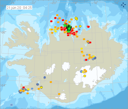
Here are the latest geological unrests and news from Iceland:
Earthquake swarm shakes northern Iceland
An intense earthquake swarm is ongoing 20km NE of Siglufjörður. Since the swarm started yesterday over 1500 earthquakes have been detected:
The two largest quakes were felt by residents in Dalvík, Hofsós, Siglufjörður, and Akureyri, and as well as those in the municipality of Hörgársveit, further inland. Neither injuries nor damage have been reported.
Officials say Grímsvötn volcano is preparing for its next large eruption. Recent gas measurements indicate there is magma near the surface of the volcano. Grímsvötn last erupted in 2011 and erupts on average every 5-10 years during active periods.
Earlier this month, scientists from the Icelandic Met Office measured sulphur dioxide (SO2) in the southwest corner of the caldera in Grímsvötn, close to where the last eruptions in 2004 and 2011 took place.
In addition to the high level of SO2, geothermal activity at the surface of the volcano has notably increased.
Moreover, scientists have shown a correlation between jökulhlaup (glacial floods) and eruptions in Grímsvötn. When the pressure in the volcanic system is increased due to magma accumulation and if a large volume of water is stored in the lake, the pressure release following the removal of water during a flood could facilitate the magma rising to the surface and trigger, in this way, an eruption.
Currently, the water level is rather high and the pressure in the magma chamber below the caldera has reached values comparable to those prior to the last eruption. Therefore, an eruption triggered by a glacial flood has to be considered.
An eruption in that area is not likely to cause much damage as they are usually small or medium-size. Moreover, Grímsvötn is far away from inhabited areas. However, a Grímsvötn would release tremendeous amount of ash, which could lead to air traffic stops and dangerous ashfall for people and livestock.
No comments:
Post a Comment