Early this morning (Sept. 6), the sun released two powerful solar flares — the second was the most powerful in more than a decade.


At 5:10 a.m. EDT (0910 GMT), an X-class solar flare — the most powerful sun-storm category — blasted from a large sunspot on the sun's surface. That flare was the strongest since 2015, at X2.2, but it was dwarfed just 3 hours later, at 8:02 a.m. EDT (1202 GMT), by an X9.3 flare, according to the National Oceanic and Atmospheric Administration's Space Weather Prediction Center (SWPC). The last X9 flare occurred in 2006 (coming in at X9.0).
According to SWPC, the flares resulted in radio blackouts: high-frequency radio experienced a "wide area of blackouts, loss of contact for up to an hour over [the] sunlit side of Earth," and low frequency communication, used in navigation, was degraded for an hour. [The Sun's Wrath: Worst Solar Storms in History]
During large solar flares, the sun can also sling a cloud of energetic plasma from its body, an event called a coronal mass ejection (CME).
"It was accompanied by radio emissions that suggest there's a potential for a CME," SWPC space scientist Rob Steenburgh told Space.com. "However, we have to wait until we get some coronagraph imagery that would capture that event for a definitive answer."
If aimed toward Earth, the CME from these latest flares could lead to even more spectacular auroras, but could also damage satellites, communications and power systems. That cloud of charged plasma would arrive within 1 to 3 or 4 days, Steenburgh said, although CMEs triggered by energetic flares generally come quickly.
Doesn’t it seem like all the disasters are coming at us at the same time? Just in case one catastrophe isn’t enough, we’ve got all sorts of other things either going on right now or headed our way. Here are 5 stories that will make you glad you’re a prepper. And if you’re not, perhaps this is a cosmic kick in the pants that is telling you that you should be.
Here are 5 epic disasters that are happening right now.
The five stories below will make you want to double down on your preparedness efforts because between mankind and Mother Nature, things are looking increasingly dangerous.
Texas was just hit with the biggest rainfall ever recorded in the Continental US.
Hurricane Harvey flooded the Gulf Coast of Texas with more rain than has ever been recorded in this country. The storm dumped 51.88 inches of rain on the state, flooding the coast and causing billions of dollars worth of damage to homes, businesses, and infrastructure. And the disaster isn’t over yet. With the flood and wind damage comes a whole new set of problems, like waterborne illness, mosquitoes, and explosions at flooded factories. (Read more about the aftermath of Harvey here.)
The Western United States is on fire.
The western half of the country is burning right now, with smoke so dense that NASA has tracked it all the way the way to western New York. More than 80 wildfires are spreading uncontrollably across California, Washington, Oregon, Idaho, Colorado, and Montana. Pair the fires with extreme heat, high winds, and very dry conditions, and it’s a recipe for an unstoppable disaster. Hundreds of homes have been destroyed, natural and historical wonders are going up in flames, and thousands of people have been evacuated from their homes. (source)
North Korea successfully tested a hydrogen bomb…and they keep threatening us.
Despite warnings from the international community, North Korea continues to behave in an increasingly aggressive fashion. In the past week, they sent a missile flying over Japan and they detonated a powerful hydrogen bomb. They’ve also pointed out that a nuke could be detonated in the atmosphere over the United States, resulting in an electromagnetic pulse that could take out our electrical grid for years.
Two X-class solar flares are headed our way.
And if North Korea doesn’t take down our grid, the sun might. The sun just released two of the biggest solar flares in a decade. Space.com reports:
There is some evidence that a cloud of plasma was released along with the second flare, called a coronal mass ejection. This could cause spectacular auroras tonight, but could also damage satellites, communications, and the electrical grid. It takes anywhere from 1-4 days for the CME to reach the earth. The issue with communications and satellites could be huge, effectively blinding us with Hurricane Irma on the way.
Hurricane Irma, one of the most powerful hurricanes ever recorded, is headed straight for Florida.
Hurricane Irma is the strongest hurricane ever measured outside of the Gulf of Mexico and the Caribbean, with sustained winds of over 185 miles per hour. Unless something major happens to steer the storm away, the storm is due to hit the Florida Keys as soon as Sunday, and since there is only one road out of the Keys, the islands are already under mandatory evacuation orders.
There are two more tropical storms close behind Irma with the potential to turn into hurricanes. Jose is on the same course but may veer North instead of hitting Florida and the East Coast. Katia is developing in the Gulf of Mexico near Veracruz.
Irma is the kind of storm where you get thousands of lives lost. This is not going to be the big slow-motion flood like Harvey - this is a real, honest-to-God hurricane.
- Chuck Watson, disaster modeler with Enki Research
Hurricane Irma, the most powerful Atlantic storm on record according to the NHC, raced across northern Caribbean islands on Wednesday with a "catastrophic mix of fierce winds, surf and rain", ahead of what appears a virtually guaranteed Florida landfall at the weekend. While Irma precise trajectory remained uncertain, the latest NHC forecast sees the cone coming right on top fo the panhandle.
.@NHC_Atlantic cone w/ #Irma & how its changed over time. Trend back to the right and a wide cone still relaying uncertainty on future track pic.twitter.com/Mr1a6CHDjx— Jim Cantore (@JimCantore) September 6, 2017
The eye of Irma, a Category 5 storm packing winds of 185 miles per hour (295 km per hour), moved away from the island of Barbuda and toward the island of St. Martin, east of Puerto Rico, early on Wednesday, the U.S. National Hurricane Center (NHC) in Miami reported. It could hit Florida on Saturday. It is expected to bring strong storm surges and up to 20 inches of rain in some places.
“We are hunkered down and it is very windy ... the wind is a major threat,” said Garfield Burford, the director of news at ABS TV and Radio on the island of Antigua, south of Barbuda. “So far, some roofs have been blown off” he added according to Reuters. Most people who were on Antigua and Barbuda were without power and about 1,000 people were spending the night in shelters in Antigua, according to Burford. “It’s very scary ... most of the islands are dark so it’s a very, very frightening,” he said.
The eye of the storm passed over St. Martin and its northern wall was pounding Anguilla, the U.S. National Hurricane Center said in an advisory around 8 a.m. New York time. It’s on a path that should pass near or just north of Puerto Rico later Wednesday, it said.
The French government has said that the four "most solid" buildings on the Caribbean island of Saint Martin have been destroyed by Irma as the Hurricane wreaked catastrophic damage in the region,
Serious flooding and building damage has affected a number of islands, French interior minister Gerard Collomb said. "We know that the four most solid buildings on the island have been destroyed which means that more rustic structures have probably been completely or partially destroyed," he told reporters. The French government has said there are electrical blackouts and widespread flooding on the islands of St Barthélemy and St Martin.
Irma spun into a monster storm Tuesday morning with sustained winds topping 180 mph, becoming the strongest Atlantic hurricane ever recorded outside the Gulf of Mexico and Caribbean, National Hurricane Center forecasters said in their 11 a.m. advisory.
As the hurricane churns closer to the U.S. coast, its path becomes more certain, with South Florida, particularly the Keys, increasingly likely to take a hit. Tropical storm force winds could arrive as early as Friday. Gov. Rick Scott has declared a state of emergency for all 67 counties and has all 7,000 members of the state’s National Guard to report to duty on Friday.
Because Irma is so large, forecasters urged caution in paying too much attention to its exact track. The storm is continuing to roll west at 14 mph, with winds expected to begin battering the Leeward Islands today. A powerful high pressure ridge is steering the storm and will likely stay in place over the next few days, forecasters said. In five days, a trough moving across the U.S. should begin weakening the western edge of the ridge, allowing the storm to slide north. Where Irma makes the turn will determine impacts to Florida.
People in Oregon wiped soot from their windshields and covered their faces with scarves to keep the choking ash of wildfires from filling their lungs, similar to what longtime residents said they had to do in 1980 during the volcanic eruption of Mt. Saint Helens.
The growing blaze east of Portland, Ore., in the scenic Columbia River Gorge, was one of dozens of wildfires in western U.S. states that sent smoke into cities from Seattle to Denver — prompting health warnings and cancellations of outdoor activities for children by many school districts.
The 16-square-mile (41-square-kilometer) fire east of Portland forced hundreds of home evacuations. And embers from the fire drifted across the Columbia River, sparking blazes in neighboring Washington state. People shielded their faces and authorities in the Northwest urged drivers to use headlights during the day to increase visibility. (AP)
The Eagle Creek Fire and Indian Creek Fire have merged into one 32,000-acre blaze in the Columbia River Gorge, CBS affiliate KOIN-TV reports.
The Indian Creek Fire began July 4 before merging with Eagle Creek Fire, according to KOIN-TV.
The blaze was 0 percent contained early Wednesday, according to the station.
Officials say the fire destroyed a small home and four other structures and is casting a haze of smoke across the Portland metropolitan area. The National Weather Service said air quality should improve in the coming days.
The Centers for Disease Control said wildfire smoke is especially dangerous for people with heart and lung diseases like asthma, KOIN-TV reports. Officials said all people in smoky areas should avoid strenuous work, exercise outdoors or driving whenever possible.
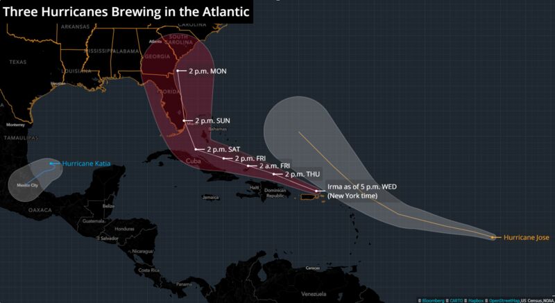
Three hurricanes are now churning in the Atlantic as the storm season is proving to be an active one.
Jose and Katia joined Irma as hurricanes on Wednesday, according to the National Hurricane Center. The last time there were three active in the Atlantic was seven years ago, according to a twitter post by Philip Klotzbach, a meteorologist at Colorado State University.
Katia is looming off the coastline of Mexico as a Category 1 storm. Jose is in the middle of the Atlantic and isn’t forecast to be a threat to the U.S. mainland. And Category 5 Irma is forecast to hit South Florida on Sunday.
To take your mind off nuclear war with North Korea and deadly hurricanes, let’s talk about other ways to cull the herd…
Scientists at the Hong Kong Polytechnic University in Hangzhou, China have discovered a new strain of antibiotic-resistant pneumonia which spreads incredibly fast, after a 2016 outbreak in a hospital ICU led to the deaths of five patients ranging in age from 53 to 73. In findings published in The Lancet, researchers conclude that the new superbug poses a “substantial threat to human health” due to the fact that it is “simultaneously hypervirulent, multidrug resistant, and highly transmissible.”
K. pneumoniae (ST11 CR-HvKP) is a triple threat; a deadly combination of two previously known strains of pneumonia; one which shrugs off all but the toughest antibiotics, and the other which is classified as ‘very severe’ and ‘hypervirulent’ in terms of lethality and how quickly it spreads.
The new report also reveals that samples from other parts of China tested positive for the new superbug, noting that “[f]ailure to control its early spread right now, will make a global epidemic of carbapenem-resistant [CRE], hypervirulent K. pneumoniae hard to avoid,” advising that “Control measures should be implemented to prevent further dissemination of such organisms.”
Epidimiologiests Liang Chen and Barry Kreisworth call the new strainof pneumoniae an “alarming evolutionary event.”
3 comments:
Just think how worried those who have rejected Jesus are, after considering all these threats to mankind right now. But the Bride is waiting eagerly for her King to bring us home to the Wedding Feast of the Lamb! It certainly can not be much longer.... see you all very soon. Maranatha!
“Here are 5 stories that will make you glad you’re a prepper.” No amount of human prepping can prepare for what's to come. Time to board the Jesus Ark before the door closes.
Amen Come Lord Jesus!
Post a Comment