A strong eruption of Fuego volcano has started on October 12, 2018, sending ash 5,000 kilometers in the air and triggering extremely hot pyroclastic flow on the flank of this extremely active peak in Guatemala. This volcanic event was followed by a strong 5.7-magnitude earthquake that struck near the volcanic peak.
The pulse of the strong earthquake has been felt in the southern areas of the country and in Guatemala City.
Over 60 people have been evacuated from their houses in Sangre de Cristo and the Palo Verde, located in the vicinity of the Fuego volcano.

The volcano spewed out a column of ash to a height of 4.8 kilometers (3 miles) and then dispersed 15 to 20 kilometers to the southwest, west of the volcanic peak. Ashfall was reported in the villages and cities around the volcano.
The explosions were accompanied by loud noises and have triggered a 1200-meter-long lava river flowing on the western flank of the volcano.
Meanwhile, the activity of the Pacaya volcano has also increased in Guatemala with many daily explosions and lava flow visible at night:
Fuego is one of the most active volcanos in Central America. Its previous eruption took place in early June affecting around 1.7 million people. In June, a devastating eruption of Fuego volcano killed more than 190 people.
The Kuril Islands and currently experiencing lots of seismic and volcanic activities in the last few days. After the M6.5 earthquake of October 10, 2018, another M6.7 earthquake hit the region. In the meantime, the Ebeko volcano, a highly active somma volcano located on the northern end of Paramushir Island, Kuril Islands, Russia, has also erupted sending plumes of ash 4,000 meters in the air.
Two days ago, 3 earthquakes greater than M6.0 and a M7.0 hit along the ‘Ring of Fire’ within just 5 hours. One of these strong shakings occurred in the Kuril Islands, Russia.
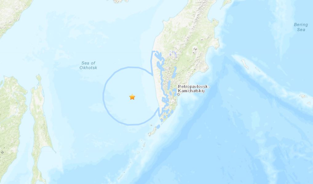
Today again, a strong M6.7 tremor was recorded off the Kamchatka Peninsula in the Sea of Okhotsk at a depth of 410 km (255 miles), so really, really deep.
Meanwhile, the Ebeko volcano erupted on October 9, 2018. Here another impressive video:

In one scenario, choppy waters brought on by the hurricane break up and disperse the red tide bloom, moving it offshore and leaving it to weaken as temperatures decrease. Moreover an oeanographer predicts the algae couldn’t survive onshore for an extended period of time, as it would be unable to find sufficient nutrients.
On the other hand, the storm could push the red bloom inland, sending toxins into the air and sparking human respiratory issues similar to those caused by tear gas. It’s also possible that heavy rains brought on by the hurricane could make septic tanks, sewage systems and ponds overflow and release nutrients that actually fertilize the red tide, making it worse.
Back in history
A similar situation may have played out in 2004, when four hurricanes hit Florida in quick succession. That year, the state experienced one of the worst red tide outbreaks in its history; a so-called “dead zone” that stretched from New Port Richey to Sarasota was declared completely devoid of oxygen and marine life.
Then again, Hurricane Katrina, a 2005 storm that devastated the Florida peninsula and Louisiana, broke up the dead zone by pushing the red tide north.
Red tides
Red tide is an annual occurrence along the southwest Florida coast. A type of algae known as Karenia brevis is responsible for the toxic bloom, which can leave waters colored with a muddy brown or red hue. In small quantities, K. brevis is relatively harmless, but under certain conditions, it rapidly reproduces and releases toxins into both the water and the air.
Fish, birds, manatees, sea turtles and pygmy whales are amongst the creatures that have fallen victims to this latest bout of red tide. Humans with existing respiratory conditions, as well as those who unwittingly consume contaminated seafood, have also been affected.
Florida’s current red tide outbreak has troubled the area for nearly a year, making it the longest one in more than a decade. Toward the middle of August, Florida Governor Rick Scott declared a state of emergency in the communities most devastated by the algal bloom, which poses a risk to not only the region’s wildlife and human communities, but the tourism industry residents rely on for their livelihood.
Ultimately, hurricanes’ impact on red tide, and more specifically, Hurricane Michael’s effect on Florida’s current algal crisis, remains difficult to predict. But this is the first time the state has had to tackle severe red tide and a severe hurricane concurrently.

No comments:
Post a Comment