The Iraqi-Iranian border region was hit on Sunday by a 6.3-magnitude earthquake, the European-Mediterranean Seismological Center (EMSC) said.
At least 70 were injured on Sunday in an earthquake 163 kilometers (over 100 miles) northeast of Baghdad and 20 kilometers southwest of the Iranian city of Sarpol Zahab, Press TV reports, citing a statement made by local officials.
Earlier in the day, the European-Mediterranean Seismological Center (EMSC) reported that tremors were registered at 16:37 GMT.
The epicenter of the earthquake was located at the depth of 10 kilometers.
According to the EMSC, the tremors were felt in Iraq, Iran and Kuwait. Iranian rescue teams have been dispatched to the quake-hit area, while there are no reports about victims and damages caused by the earthquake.
An earthquake with a magnitude of 6.3 has shaken western Iran, 114km northwest of the city of Ilam, near its border with Iraq. At least 115 were injured in Sarpol-e Zahab and the neighbouring Gilan-e Gharb city. No casualty has been reported so far. The quake struck the same area where another tremor killed over 600 people last year.
Morteza Salimi of Iran’s Red Crescent told state TV that since the area was reconstructed after the last year’s quake, officials hope there won’t be casualties.
Security camera footage from grocery store in Sarpol, Iran shoes aftermath of earthquake pic.twitter.com/vig7XXZ2Wg

 (@borzou)
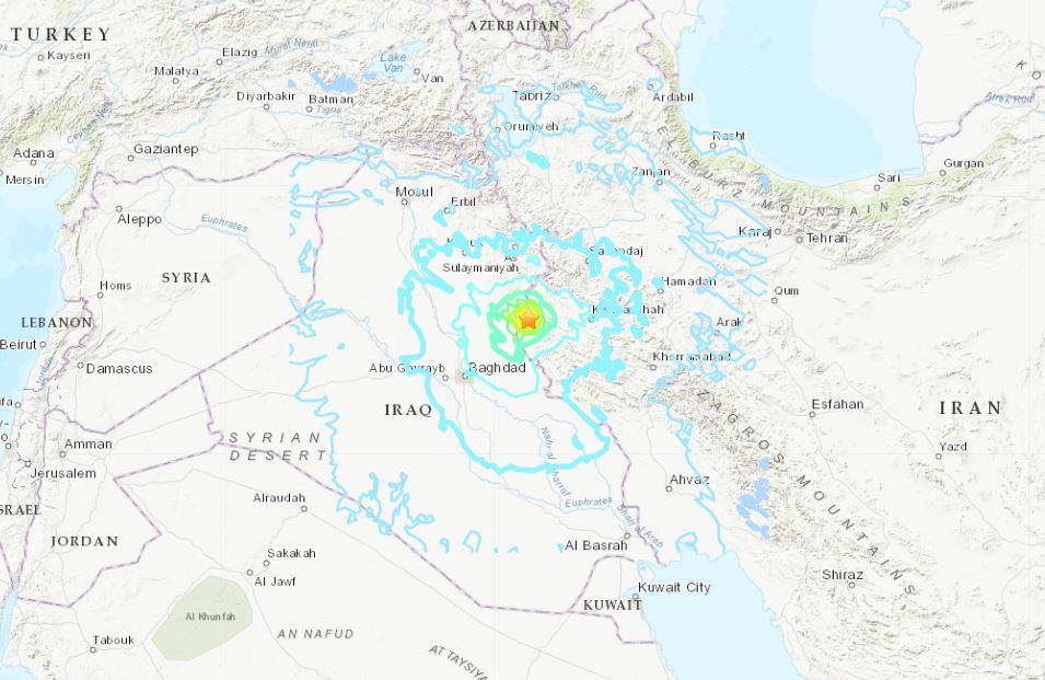
Ali Moradi, head of Iran’s seismology centre, told state TV “the quake was not near bigger cities. But it might have caused damage in villages and I hope not that many villages are located where it hit.“
The Iraqi state media said the tremor was felt in capital Baghdad and in Erbil in the Kurdistan region.
Many videos from Snapchat from Baghdad showing the power of the magnitude 6.3 earthquake that struck the Iran Iraq border just now… scary stuff. #earthquake #earthquakeiran #earthquakeiraq #earthquakeiraniraqpic.twitter.com/1S0GHQVsCb— Mikey(@MambaMike13) November 25, 2018
People were seens running out of their homes in Kurdistan:
A 6.3 magnitude earthquake on the Iran-Iraq border forces people to flee their homes in the Kurdistan Region’s Garmiyan region. Some report the tremor was felt in the capital Erbil. #TwitterKurdspic.twitter.com/ueVNL0D505— Karzan Sulaivany (@KarzanSulaivany) November 25, 2018
A 6.0-magnitude earthquake struck off the coast of Colombia on Saturday, according to a preliminary report from the US Geological Survey.
The quake struck in the Caribbean Sea near the island of Providencia and about 19.9 miles (32 kilometers) from Mountain, Colombia, according to the USGS.
The USGS also said the earthquake had a depth of 6.2 miles (10 kilometers). Earthquakes can occur anywhere from zero to 487 miles (800 kilometers) below the earth's surface, according to USGS.
The National Tsunami Warning Center said the earthquake is currently not expected to generate a tsunami and there is no tsunami danger for the US east coast, the Gulf of Mexico, or the eastern coast of Canada.
Likewise, the governorship of the province of San Andrés Archipelago, Providencia and Santa Catalina, said no tsunami alarm has been issued for Colombia's Caribbean coast, according to a tweet from Colombia's National Unit for Disaster Risk Management (UNGRD).
No comments:
Post a Comment