Today, scientists say that the 150-mile-long New Madrid Seismic Zone has a terrifying 40% chance to blast in the next few decades, impacting 7 states – Illinois, Indiana, Missouri, Arkansas, Kentucky, Tennessee and Mississippi – with 715,000 buildings damaged and 2.6 millions of people left without power.
We all know the awesome power of the San Andreas fault. But there’s a fault in the Midwest that packs an even greater punch.
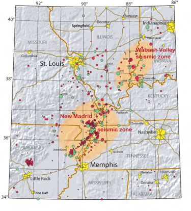
The New Madrid Seismic Zone, sometimes called the New Madrid Fault Line, is a major active seismic zone in the southern and midwestern United States. As shown in the map above, it stretches to the southwest from New Madrid, Missouri. Earthquakes that occur in the New Madrid Seismic Zone potentially threaten parts of 8 US states: Illinois, Indiana, Missouri, Akansas, Kentucky, Tennessee, Oklahoma, Mississippi.
The New Madrid fault system was responsible for the 1811–12 New Madrid earthquakes, an intense intraplate earthquake series that began with an initial earthquake of moment magnitude 7.5–7.9 on December 16, 1811, and was followed by a moment magnitude 7.4 aftershock on the same day. They remain the most powerful earthquakes to hit the contiguous United States east of the Rocky Mountains in recorded history.
Unlike California, which has been super-prepared since the last major earthquake hit hard enough to delay the World Series, the New Madrid fault area has been sitting blissfully by.
In case the “40 percent” statistic didn’t bother you, this should: The New Madrid fault has an impact zone ten times as big as its more famous San Andreas cousin and most residents from all of the bordering states on the fault are totally unprepared, and the infrastructure is decades overdue for some quakeproofing.
The unique geology in the Midwest increases the shaking intensity of earthquakes because energy from the New Madrid seismic zone moves through the dense bedrock underlying the mid-continent region at very high speeds, then becomes trapped in the soft sediments filling river channels and valleys.
Ground shaking would be magnified about 600 percent within the flood plain of the Missouri River, a development that would predict soil liquefaction and cause most of Missouri’s existing long-span bridges to collapse.
Northwest FEMA Director Kenneth Murphy said that this natural disaster along the Cascadia Subduction Zone – a major fault line that runs from Northern California to British Columbia – is set to kill around 13,000 people and injure another 2,500. This has prompted the Cascadia Preparedness Team to draw up urgent plans to prepare for the apocalyptic scenario.
Yumei Wang, from the Oregon Geology and Mineral Industries, said that the major earthquake is more than 50 years overdue.
Now, the state is promoting a two-week readiness campaign for people to ready themselves to be self-sufficient for the 2 weeks. Steve Robinson, the President of Cascadia Prepared, said: “People don’t really understand that there will be thousands of bridge failures and there won’t be any liquid fuel or electricity or any communication going. Running water may stop and it may take several days for responders to start helping with rescues and evacuations.“
Research has shown that this faultline has generated a major earthquake (over magnitude 7.5) at least 40 times in the past 10,000 years, meaning they occur every 250 years. The last earthquake, which struck 300 years ago, lowered the Oregon coastline by several feet and caused a massive tsunami. It is thus overdue by more than 50 years now!
The quake is predicted to last only four minutes with a magnitude up to 9.2. When this happens, the northwest edge of our continent will drop as much as six feet and rebound thirty to a hundred feet west.
Not only will this cause landslides but some of this will happen beneath the ocean, which will cause an enormous displacement of water. The water will rise into a massive hill and have one side go toward Japan while the other 70 foot tall liquid wall goes toward our northwest coast, averaged to come in fifteen minutes after the earthquake began.
The on the Northwest Coast of America is 70 years past due for a Major seismic event. This is a real computer generated model of what a resulting tsunami would actually look like after a major earthquake along the Cascadia Subduction Zone:
The FEMA director for the northwest Kenneth Murphy said that everything west of I-5 will be, “toast.” The area will be completely unrecognizable after everything has subsided.
No comments:
Post a Comment