- The Northeast is currently being battered by a severe winter storm that started early Thursday morning
- A rapid plunge in pressure has caused a 'bomb cyclone' system of fast heavy snowfall and winds up to 76 mph
- Boston experienced historic flooding as floodwaters hovered close to 15.1 foot mark similar to Blizzard of 1978
- Three people were killed in North Carolina, one in South Carolina, and two in Virginia, officials said
- The storm has caused traffic chaos as plows work around-the-clock to try and keep roads clear
- More than 4,000 flights in and out of the US today have been cancelled thanks to the storm
- All flights in and out of JFK and LaGuardia Airports in New York City have been temporarily suspended
- Schools were ordered closed in New York, many parts of New Jersey, Boston and elsewhere in the region
- Temperatures are expected to stay well below freezing throughout the weekend, with parts of New England registering temperatures colder than Mars
- On Thursday, New York Gov Andrew Cuomo declared a state of emergency for several counties
- Meanwhile, Florida, Georgia and SC continue to dig out of the rare winter storm that hit them Wednesday
Boston experienced historic flooding on Thursday, as a 'bomb cyclone' winter storm hit the Northeast, bringing heavy snow, winds and storm surge.
Meteorologists said Boston was unofficially nearing a water level record set during the Blizzard of 1978.
Matt Doody, a meteorologist at the National Weather Service in Taunton, told the Boston Herald that the Weather Service couldn't 'officially' call it a new record, but the water was hovering around the 15.1 foot mark set during the historic storm 40 years ago.
The system is also very similar to a storm that hit the Northeast on the exact same day in 1989, according to the Weather Service.
At least a dozen people have been rescued from flooded homes in Marshfield, and a handful of others were rescued from cars under water in the South Shore region of Massachusetts.
'It's up over the roof of cars. It's up over four feet,' Deputy Fire Chief Louis Cipullo said of the floodwaters in the area.
The nor'easter threatened to dump as much as 18 inches of snow from the Carolinas to Maine - causing schools and office to close and thousands of flights to be cancelled.


The East Coast "bomb cyclone" on Thursday looks both beautiful and sinister from space.
While scientists have been tracking storms using satellites in orbit for decades, they now have a brand new tool at their disposal: GOES-16, also called GOES-East.
The brand new satellite — which wasn't available to scientists last winter — is one of the most powerful weather-watching tools in history, able to take snapshots of the storm every minute.
The storm, which is bringing blizzard conditions to areas from Virginia to Maine, along with hurricane-force wind gusts and damaging coastal flooding, looks like a classic non-tropical storm. It took on a comma shape, drawing in moisture all the way from the Bahamas, and dumping it into an Arctic air mass in place over the Mid-Atlantic and East Coast.

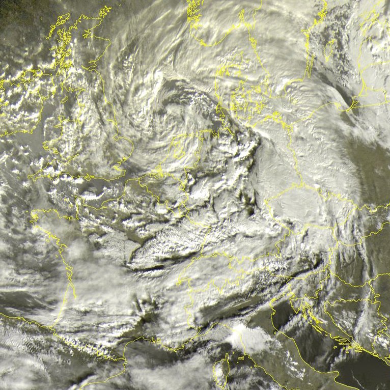
The winter storm Eleanor tore through Europe on Wednesday with winds of up to 100 miles per hour, bringing lightning and heavy rain, battering houses with hail, flooding streets and uprooting trees. The storm — named Burglind in Austria, Germany and Switzerland — arrived in tandem with a cold front, hitting Ireland before passing through Britain and on to Continent. Travelers were delayed, and adverse weather was expected to be felt as far north as the Baltics and as far south as Italy. Weather warnings were the order of the day, with forecasts of violent winds, mostly in coastal areas. Workers raced to restore power to thousands of homes, and to clear highways and train tracks of trees and overturned vehicles.
Winter storm Eleanor – an extratropical cyclone – has swept into most of northern Europe, including France and Germany after battering the UK, cutting power to tens of thousands of homes and affecting transport.
There are currently about 50 injured across the countries hit, but the numbers may increase as the storm is going to continue in the next 2 days. The storm – named Burglind in Austria, Germany and Switzerland – killed a skier in the French Alps and 15 others were injured elsewhere in the country, four of them seriously. A train was blown off its tracks in Switzerland, leaving several people with minor injuries. One person was hit by a falling tree in the Netherlands.
The maximal wind gust recorded was measured at a speed of 226 km / h in Switzerland and the minimum pressure of the storm was 967 hPa. At least 7 tornadoes were reported in Belgium, the Netherlands and Germany.
France
In northern France, the storm cut power to more than 200,000 households and Eleanor is set to move to other regions throughout the day, including Corsica. Air travel was also disrupted in the capital, Paris, and in the east of the country.
In Paris, the Eiffel Tower was closed because of the strong winds. The city’s parks have also been closed until the storm dies down because of worries over falling tree branches.
Germany
In Germany, the storm – named Burglind there – has swept over much of the country. It packed gusts of more than 120km/h in the west of the country and led to transport disruption, reports say.
Switzerland
Switzerland has also been badly hit, with some 14,000 homes without power. The high winds left several people stranded in a ski lift in St Gallen canton, overturned a light airplane in Stans and several trucks on highways, derailed the lead car of a regional train near Lenk and snapped the 13m (42ft) high Christmas tree in the capital Bern. And here you go:
Meanwhile, wind gusts on the Pilatus peak near Lucerne hit 226 kmh, the highest there since records began in 1981.


Belgium and Netherlands
Belgium was put on “orange” alert, the third of four warning levels, with officials urging people to be cautious when going out because of tree branches and other flying objects.
In the Netherlands, gusts of more than 110km/h (68mph) were recorded as hundreds of flights were cancelled at Amsterdam’s Schiphol airport.
UK and Ireland
In the UK thousands of homes are without power and travel has been disrupted after Storm Eleanor hit there.
The Met Office recorded gusts reaching 100mph (161km/h) overnight with a weather yellow warning still in place for Wales, England, most of Northern Ireland and parts of southern Scotland.
In the Republic of Ireland, 97mph gusts were recorded, and there was flooding, travel disruption and damage to buildings. In Galway, Ireland’s fourth largest city, 150,000 homes were without power on Tuesday. Now more than 27,000 homes are still without electricity.
An apocalyptic hailstorm accompanied by heavy rains surprised the inhabitants of Biblián, in the province of Cañar, Ecuador on January 2, 2018 afternoon, at around 4:00 p.m. The most intense rainfall that has been recorded in the last 15 years in the city lasted a little more than an hour, but with such a fury that it completely buried cars in a hell lot of hail! Here some pictures and videos reporting the unbelievable hail accumulation:
The strong rain and hail started at 4:30 pm and ended after about an hour, enough time to flood the streets and collapse the sewers. A woman fell in the Burgay River, but was rescued at an hospital. Some however started building hail catles and other funny things. Now, here a few pictures:


The Thomas fire is California’s largest wildfire on record, burning more than 280,000 acres during its destructive march across Ventura and Santa Barbara counties. The U.S. Geological Survey has studied the fire’s burn area to determine its vulnerability to flash floods, mudslides and debris flows. Using burn severity, soil properties, rainfall data and a number of other factors, scientists have estimated the likelihood of a debris flow based on a peak 15-minute rainfall intensity of 24 millimeters per hour.


Mount St. Helens is rumbling again, experiencing more than 70 earthquakes since New Years Day and aftershocks continuing every few hours. The seismic swarm largest quake – a M3.9 tremor – struck 5 miles from the active stratovolcano located in Skamania County, Washington, in the Pacific Northwest region of the United States.

The strongest M3.9 tremblor was felt in Portland but there were no reported injuries or damage. Since that earthquake, there have been 60 more earthquakes, averaging about every half hour with magnitudes from 0.6 to 2.6.
The USGS reports that the M3.9 earthquake to the northeast of Mount St. Helens is aligned with regional stress as opposed to the localized Mount St. Helen’s stress axis, thus, they do believe this earthquake is related to the nearby volcano.
It is common to experience swarms of earthquakes at Mount St. Helens. The recent earthquakes appear to be both from regional stress (i.e. not related to the volcano) and from the volcano itself.
Mount St. Helens is most commonly known for its major eruption in 1980, the deadliest and most economically damaging volcanic event in the history of the United States. The stratovolcano is situated just 96 miles from Seattle and 50 miles from Portland, making an eruption especially dangerous.
While Mount St. Helens hasn’t had a large eruption for the past almost 38 years (there have been smaller eruptions as recently as 10 years ago) it is still considered an active stratovolcano by geologists. In fact, Mount St. Helens is considered a relatively young volcano, forming in the past 40,000 years and has been the most active volcano in the Cascade Range within the past 10,000 years.
This mountain range, along with Mount St. Helens, will continue to experience active volcanism and deadly eruptions as long as the Juan de Fuca Plate is subducting underneath the North American Plate. The dense, relatively thin, and low lying Juan de Fuca Plate is being pushed against and under the thicker and less dense North American Plate. This is due to the continuous spreading and opening of the Pacific Ocean, which has resulted in the Pacific Ring of Fire.
No comments:
Post a Comment